HuntIntel Hunting Assistant
Premium maps for less, AI hunting assistant, hunting terrain and trail camera analysis, plus powerful hunting club management tools.
Premium maps for less, AI hunting assistant, hunting terrain and trail camera analysis, plus powerful hunting club management tools.
AI-powered scouting and terrain analysis for hunters, Search & Rescue, and outdoor professionals. Analyze entire properties in minutes from your phone or PC.
HuntIntel brings the information around your hunt into one place. Understand terrain, plan around weather and access, manage personal or club properties, coordinate hunters, and keep a useful record of what happens in the field.
HuntIntel is not just a map or a chat tool. It connects land, conditions, people, and field observations so the information you collect becomes useful on the next hunt.
Use hunting maps and terrain layers to see the property more clearly before entering it.
Use AI to turn terrain, weather, timing, and your field context into a practical strategy.
Manage personal properties or invite a group into a shared property and club workspace.
Record what hunters and cameras observe so useful patterns do not disappear after the hunt.
Select a saved property or draw a bounded analysis area, choose whitetail deer or turkey, and tell HuntIntel what you want to evaluate. The AI Hunting Assistant combines terrain, elevation, current weather, and your selected hunt windows to identify promising areas and approaches.
Terrain Analysis is included with annual Maps + AI plans. Start with 7 days free, then your selected plan renews automatically unless canceled before the trial ends.
Use HuntIntel Terrain Intelligence for a dedicated one-time property analysis with deeper reporting, recommended waypoints, field navigation, and a downloadable PDF.
Advanced Terrain Analysis
Need a more detailed terrain analysis?
HuntIntel Terrain Intelligence is a dedicated web application powered by the HuntIntel Terrain Intelligence Engine (HTIE).
Draw a property or terrain boundary, confirm the acreage and one-time price, and receive an interactive terrain analysis with identified terrain features, recommended waypoints, field navigation, and a downloadable PDF report.
Unlike the analyses included with Maps + AI plans, Terrain Intelligence can be purchased individually whenever you need a detailed analysis. No subscription required.
Available today on desktop and mobile web. Native iPhone and Android apps are coming soon.
No subscription required.
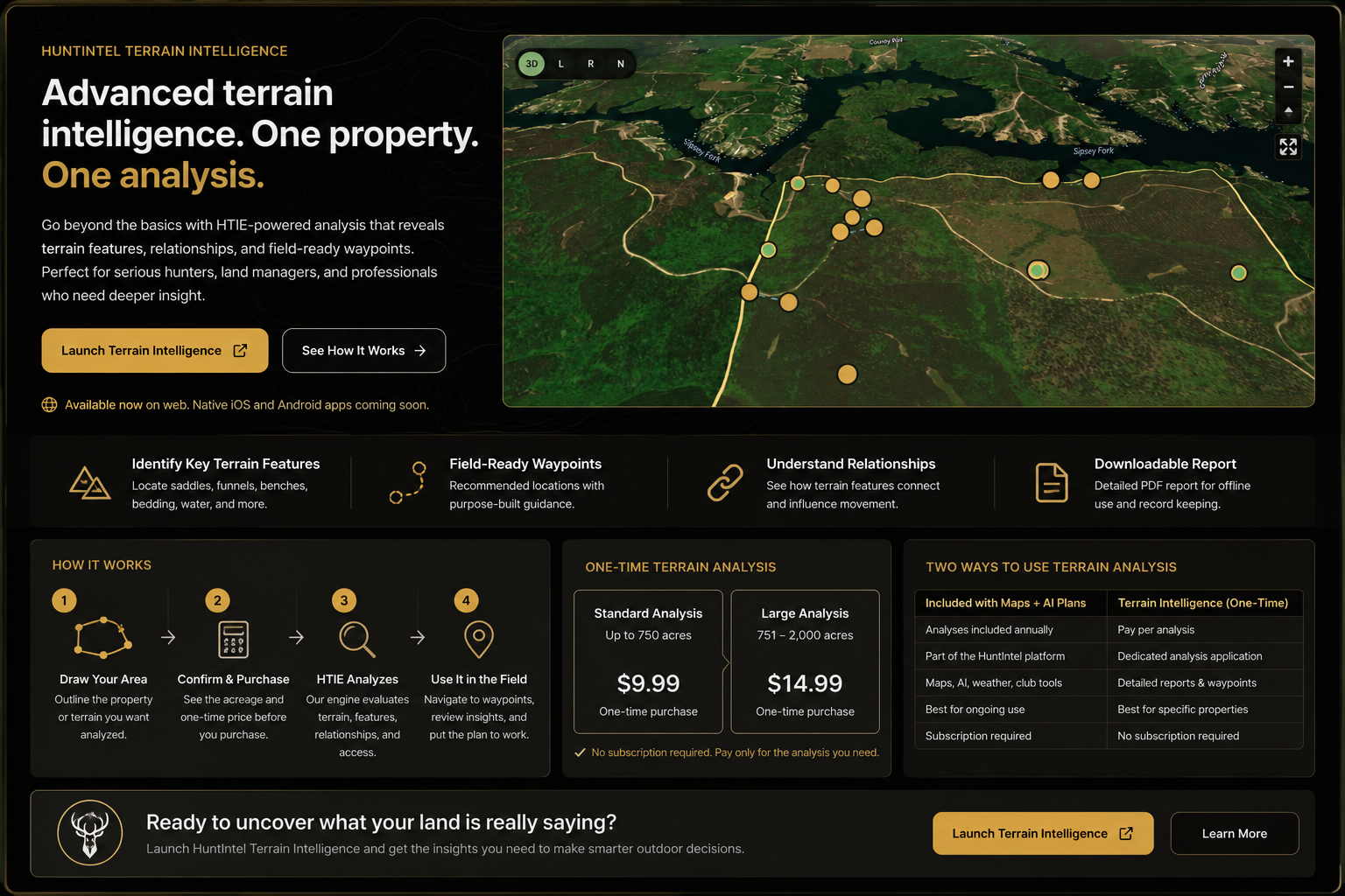
Outline the property or project area directly in the standalone web app.
Review the calculated acreage and one-time analysis price before purchase.
HTIE evaluates terrain features, relationships, and recommended waypoint opportunities.
Open the interactive map, review the PDF report, and navigate toward recommended waypoints.
Native iPhone and Android apps are coming soon. Mobile web users can enable location services to view their position on the analysis map and navigate toward recommended analysis waypoints.
Always verify access, property boundaries, terrain conditions, and local regulations before traveling to a recommended location.
HuntIntel Hunting Assistant is built for ongoing scouting and property management. Terrain Intelligence is built for individual property analyses without a subscription.
HuntIntel Maps combines premium basemaps, property boundaries, terrain layers, and a large hunting-specific waypoint library. Personal scouting stays private by default, while club owners and admins can deliberately share the information their members need.
Choose the map coverage you need. Each annual plan includes AI messages and Terrain Analysis credits.
You do not need to run a hunting club to use HuntIntel management tools. Create personal properties for yourself, or create a shared workspace and invite members at no cost to them. The workspace owner pays for the management plan; invited members can participate without purchasing the same plan.
Add management when you need shared properties, members, reservations, check-ins, rules, and storage.
Give your assistant a name and use it to think through weather, timing, movement, sightings, terrain, access, and strategy. HuntIntel can analyze a 7-day forecast by ZIP code, let you select the days you want to hunt, and carry those conditions into a focused strategy conversation.
Start with 7 days free on a Maps + AI annual plan based on the coverage you need. If you do not cancel before the trial ends, your selected plan renews automatically. Add Property / Club Management when you want to coordinate members, guests, reservations, rules, and shared properties.
Every Maps + AI plan includes premium hunting maps, weather-aware strategy tools, waypoints, and AI Hunting Assistant access. Choose the coverage and included AI capacity that matches where you hunt.
| Included | One State / Province 7 days free, then $17.99/yr |
Two States / Provinces 7 days free, then $29.99/yr |
USA + Canada 7 days free, then $59.99/yr |
|---|---|---|---|
| Premium map coverage | 1 selected state/province | 2 selected states/provinces | USA + Canada |
| Satellite, outdoors, street, and topo-style basemaps | Yes | Yes | Yes |
| LiDAR basemap | Yes | Yes | Yes |
| Hillshade, slope, aspect, and TPI terrain overlays | Yes | Yes | Yes |
| 3D map viewing on maps and property pages | Yes | Yes | Yes |
| Private properties, boundaries, and saved map preferences | Yes | Yes | Yes |
| Hunting waypoint library with notes and color choices | Yes | Yes | Yes |
| Private, club-shared, and temporary waypoints | Yes | Yes | Yes |
| 7-day hunt weather analysis by ZIP code | Yes | Yes | Yes |
| Selectable weather days added to AI strategy | Yes | Yes | Yes |
| AI Hunting Assistant messages included | 100 / year | 250 / year | 750 / year |
| AI Terrain Analysis included | 1 / year | 2 / year | 3 / year |
| Terrain Analysis features | Bedding, saddles, pinch points, entry paths, and more | Bedding, saddles, pinch points, entry paths, and more | Bedding, saddles, pinch points, entry paths, and more |
| Whitetail deer and turkey analysis | Yes | Yes | Yes |
| Morning, afternoon, and evening approach planning | Yes | Yes | Yes |
| Trail camera image analysis | Yes | Yes | Yes |
| Extra AI message and terrain-analysis top-ups | $4.99 packs | $4.99 packs | $4.99 packs |
| Web, iPhone, and Android access | Yes | Yes | Yes |
One State / Province and Two States / Provinces plans require you to choose your covered states or provinces after purchase. Coverage is locked once saved.
Start with your own maps, properties, and field records. Add AI guidance or invite a group when you need more analysis and coordination.
Open HuntIntel on the web or download the app, create your first property, and start building a hunting workspace that gets more useful every time you use it.
